


Research Spaces
Department of Geography and Anthropology faculty coordinate research labs, serve as editors of scholarly journals, and cultivate collaborative research opportunities, spaces, and places. Learn more about these activities below, many of which present opportunities for student research experiences and engagement, as well as points of interdisciplinary collaboration.
-
3D Printing Lab - Social Sciences room 3016
Contact: Prof. Uli Ingram
-
Archaeological Field Experiences
Contact: Dr. Terry Powis or Dr. Teresa Raczek
-
Archaeology Lab - Social Sciences room 4080
Contact: Dr. Terry Powis or Dr. Teresa Raczek
-
Biogeography Inventory Research and Dendrology Studies (BIRDS)
The Biogeography Inventory Research and Dendrology Studies (BIRDS) is a consortium of faculty and students that work together to investigate how and why species exist where they do (both spatially and temporally). BIRDS members look at how geography plays a role in species distribution. Current research projects include the composition and structure of (sub)urban forests, as well as the geographies of fermentation and the origin of ingredients used in creating beer, wine and other fermentable appellations.
Field-based research is conducted at the Forest Inventory Research Plots (FIRPs), established within the KSU Arboretum and the KSU Field Station. The two BIRDS research labs include the KSU Field Workshop, located at the KSU Field Station, and KSU Tree Ring Lab, located on the KSU campus. While most BIRDS findings are published and/or presented at conferences, a series of BIRDS-related maps can be found via the KSU Geospatial Sciences Mapping Portal.
Contact: Dr. Nancy Hoalst-Pullen
-
Biological Anthropology Lab - Social Sciences room 3019
Contact: Dr. Alice Gooding or Dr. Susan Kirkpatrick Smith
-
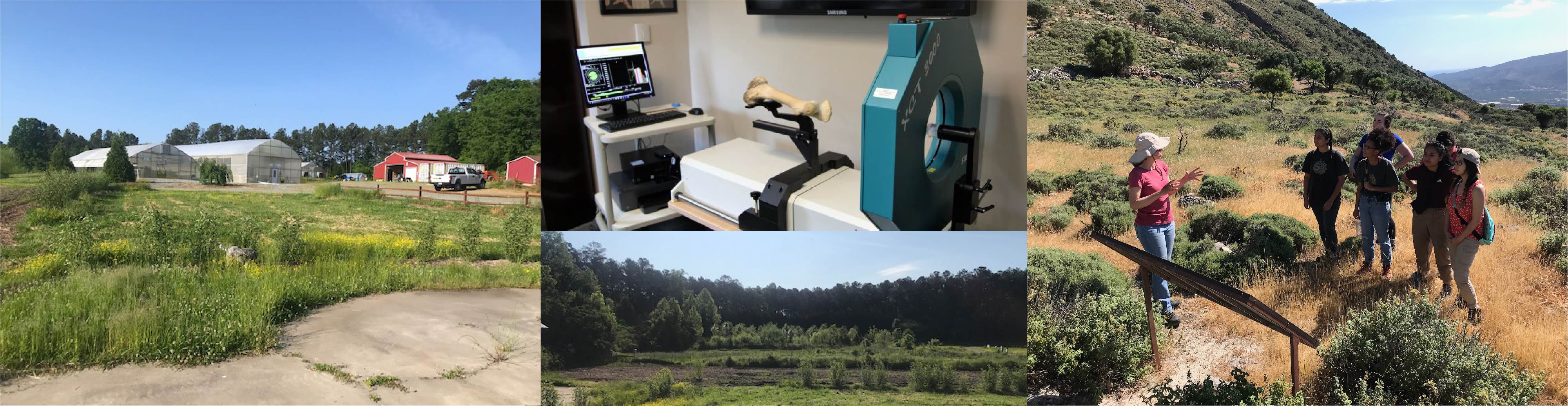
Bone Biomechanics Lab - Social Sciences Lab Complex at 1150 Chastain Rd., Kennesaw, GA 30144
Housed in the KSU Social Science Lab Complex, the Bone Biomechanics Lab investigates sport as a model to understand human evolutionary adaptation. That is, we are interested in how the bones of modern people can be used to interpret how past peoples got their food and moved across the landscape.
Lab Equipment:
Stratec pQCT XCT 3000 scanner- This CT scanner is designed to capture bone (fat and muscle to a lesser extent) imaging in the forearm and lower leg of living participants. We have also outfitted the scanner to image dry skeletal material, including crania.
Microscibe G2 Digitizer- A digitizer captures points in space for collecting metric data from three-dimensional objects. For example, craniometric measurements usually taken by hand with calipers can be gathered using the digitizer for increased accuracy, precision, and range of measurements.
Avizo 3D Visualization and Analysis Software- Researchers have a dedicated workstation with Avizo. Current projects include building models of crania from CT scans and testing long bone cross-sectional geometry.
Osteometric Tools and Comparative Skeletal Collections- For effecient collection of bone measurements, SkeVar has osteometric boards and highly-calibrated spreading calipers available. We house a relatively large collection of skeletal remains for teaching, training, and comparative data collection.
Contact: Dr. Alice Gooding
-
Community Geography
Community Geography is a result of community-driven collaborations among faculty and students that utilize geographical thinking, analytic, and problem-solving skills to research, map, analyze, and provide fresh and insightful perspectives on issues of concern to communities in metropolitan Atlanta, Georgia.
Contact: Prof. Uli Ingram, Dr. Paul McDaniel, Dr. Jason Rhodes, Dr. Vanessa Slinger-Friedman
-
Economic Anthropology
Economic Anthropology, edited by Dr. Brandon D. Lundy, is published by the Society for Economic Anthropology (SEA) to make available research that is innovative and interdisciplinary and focused on economic and social life to serve scholars, practitioners, and general audiences. Contributors to the journal represent a wide range of disciplines including cultural anthropology, archaeology, sociology, demography, economics, ecology, geography, and history. In 2017, Economic Anthropology doubled its annual publication list from one to two: a theme-based issue pegged to the annual conference, and a new Open Submission issue representing a wide variety of research engaged with economy and society.
Contact: Dr. Brandon D. Lundy
-
KSU Field Station - 1875 Hickory Grove Rd NW, Acworth, GA 30102
The Kennesaw State Field Station, managed by the Office of Research, is a 25-acre property located along a tree-lined road parallel to Interstate 75 approximately two miles from the Kennesaw Campus. The mission of the Kennesaw State University Field Station is to provide a living laboratory for researchers, educators, and students, promoting an interdisciplinary learning environment conducive for experiential academic experiences and strategic collaborations within the university community and beyond. The KSU Field Station’s goal is to support safe and sustainable communities through research, education, and civic engagement, while also addressing the instructional and research needs of Kennesaw State University.
Faculty in our department are partnering with the KSU Field Station on a variety of teaching, learning, and research opportunities, including a food forest and sustainability issues (Dr. Vanessa Slinger-Friedman and Dr. Jason Rhodes), the Forensic Anthropology Field Lab (Dr. Alice Gooding) and two Forest Research Inventory Plots (Dr. Nancy Hoalst Pullen).
Contact: Dr. Alice Gooding, Dr. Jason Rhodes, Dr. Vanessa Slinger-Friedman, Dr. Nancy Hoalst-Pullen
-
KSU Field Workshop - 1875 Hickory Grove Rd NW, Acworth, GA 30102
The Field Workshop houses an assortment of field and dendrochronology-related workshop/woodworking equipment. This lab supports field research at the FIRPs, particularly investigations into forest dynamics, land and climate histories, and environmental change.
Faculty and students are welcome to work within the lab as members of BIRDS, via a DAR (GEOG 4100 or GIS 4100), or when taking GEOG 3900 Biogeography.
Contact: Dr. Nancy Hoalst-Pullen -
KSU Food Forest - 1875 Hickory Grove Rd NW, Acworth, GA 30102
The KSU Food Forest is a 1/3 acre sustainable permaculture plot at the KSU Field Station that mimics a natural forest ecosystem and provides a model of sustainable cultivation. Planted with fruit and nut trees as well as perennial food plants, it facilitates research, training, classes, and community programs on equitable and sustainable urban/suburban food systems. Please visit the KSU Food Forest website for more information. Follow the KSU Food Forest on Instagram (@KSUFoodForest) and YouTube.
Please contact Dr. Jason Rhodes (jrhode22@kennesaw.edu) and Dr. Vanessa Slinger-Friedman (vslinger@kennesaw.edu) if you are interested in research collaboration, professional development opportunities, or volunteer opportunities at the KSU Food Forest.
-
Forensic Anthropology Field Lab (FAFL) - 1875 Hickory Grove Rd NW, Acworth, GA 30102
The Forensic Anthropology Field Lab (FAFL) at the KSU Field Station provides opportunities in research, training and service related to forensic anthropology and associated disciplines. Our field lab includes a variety of open, wooded and underground environments to facilitate cutting-edge research and training in clandestine grave recovery
To find out more, click here.
Contact: Dr. Alice Gooding
-
Forest Inventory and Research Plots (FIRPs)
Forest Inventory and Research Plots (FIRPs) are a series of 50m x 50m long term (permanent) plots used to establish the composition and structure of (sub)urban forest stands. FIRPs are located within the KSU Arboretum (established 2008) and the KSU Field Station (established 2020). FIRPs are surveyed every 2-3 years, with all tree stems identified, measured and mapped.
Faculty and students are welcome to work at a FIR-Plot(s) as members of BIRDS, via a DAR (GEOG 4100 or GIS 4100), or when taking GEOG 3900 Biogeography.
Contact: Dr. Nancy Hoalst-Pullen -
The Geographical Bulletin
The Geographical Bulletin is a scholarly, double-blind peer-reviewed journal published twice a year by Gamma Theta Upsilon (GTU), the international honor society of geography. Additional special issues may also be published throughout the year. The scope and aims are broad, as articles concerning any area of geographical or geospatial interest are solicited. While all researchers interested in geography can submit research articles and/or geographical essays, the journal champions high quality student-written and student-led research. As part of GTU's wider mission, The Geographical Bulletin offers all articles online and free of charge, with open access to ensure accessibility for all.
Contact: Dr. Nancy Hoalst-Pullen or Dr. Mark Patterson. -
Geospatial Sciences (GSS) Lab - Social Sciences room 3022
Our state of the art GSS Lab includes 4 servers and 28 workstations. Each workstation has the following software installed: ArcGIS, ArcView, Erdas Imagine, Office 2007, as well as other software programs used in various GSS classes. In addition to the workstations there are 2 large format color plotters, 2 networked black & white Laser Jet printers, 1 networked color Laser Jet printer and a scanner. Students have access to a 3-D printer for projects and research opportunities. GIS students have 24/7 access to the secured lab.
Contact: Prof. Uli Ingram
-
Geomorphology Lab - Visual Arts room 108
The Geomorphology Lab facilitates investigations into stream and river systems, soils, and paleoenvironments of the southeastern US, with current research centered around two main themes: 1) investigating stream and river response to environmental change, including past climatic change, and 2) using geomorphic techniques to evaluate rates and pathways of soil formation, assess causes of soil variability, and identify soil properties useful for geologic mapping applications.
The Geomorphology Lab is housed in Room 108 of the KSU Visual Arts Building on the Kennesaw campus and is equipped for standard analysis of soil and sediment in support of faculty and student research related to this work. The lab contains a full size fume hood, sinks with hot and cold water, a top-freezer refrigerator, two sonic sifter sieving devices, multiple sieve sets, one analytical and two precision balances, three reciprocating shakers, two drying ovens, a benchtop muffle furnace, a centrifuge, a stereomicroscope, an ultrasonic bath, standard glassware, and other laboratory hardware. Field equipment includes various augers for soil sampling, a Russian peat corer, handheld GPS units, and surveying equipment.
Contact: Dr. Bradley Suther
-
Georgia Immigration Research Network (GIRN)
Founded in 2015, the Georgia Immigration Research Network (GIRN) brings together faculty and student researchers and practitioners working on and interested in immigration and refugee research and policy as it relates to Georgia and the U.S. South. The overall purpose of GIRN is to bring together those working on and interested in immigration policy as it relates to Georgia and the U.S. South, immigrant and refugee integration in Georgia and the U.S. South, and issues of concern to immigrant and refugee populations in Georgia, as well as the human, social, and/or service needs for immigrant populations.
Contact: Dr. Paul McDaniel
-
Osteology Field School - Island of Crete in Greece
Dr. Susan Kirkpatrick Smith regularly leads students in an Osteology Field School experience on the island of Crete in Greece. Dr. Smith has much experience in Greece, having worked for the Institute for the Study of Aegean Prehistory in Pacheia Ammos, Crete since 2007. She has supervised field schools or study abroad programs in Greece since 2006.
Contact: Dr. Susan Kirkpatrick Smith
-
Skeletal Variation Research Group
The goal of the Skeletal Variation Research Group (SkeVar) is to investigate bone-related questions and provide students and professionals with top-notch training, mentoring, and teaching. SkeVar members develop foundational knowledge in skeletal anatomy and human variation, and build transferable skills in experimental design, curation, and scientific writing.
SkeVar has two main disciplinary foci- static bone biomechanics and forensic anthropology. Students studying medicine, kinesiology, biology, or other clinical research learn to collect biometric data and CT scans from living participants. Students with an inclination towards osteology learn how to collect metric data from skeletal material and perform field research in clandestine grave recovery.
The Skeletal Variation Lab includes a pQCT XCT 3000 scanner and workstation, space and equipment for data collection from skeletons, a digitizer for taking skull measurements, and a workstation for analysis and 3D modeling of bones. Student research out of the lab has been presented at the annual meetings of the American Association of Physical Anthropology, American Academy of Forensic Sciences, and the Georgia Academy of Sciences. Those interested in using the lab's equipment and technologies for their own project or joining one of the research teams should contact Dr. Alice Gooding. We welcome researchers from outside of the department and the university.
The Bone Biomechanics Lab is located in the Social Science Lab Complex at 1150 Chastain Rd., Kennesaw, GA 30144
Contact: Dr. Alice Gooding
-
Student Research Lab - Social Sciences room 3002
This lab consists of high performance computers for projects involving very high graphic rendering and memory utilization. Students are getting research training in 3D landscape modeling of point cloud data ranging from 100 gigabytes to terabytes in size.
Contact: Dr. Ranbir Kang or Prof. Uli Ingram
-
Tree Ring Lab - Social Sciences room 3022A (inside the GSS Lab SO 3022)
The Tree Ring Lab (previously known as the Dendrochronology Lab and Tree Core Bank) houses dendrochronology-related laboratory equipment (Velmex, boom microscope and various size borers) as well as an archive of tree cores from Georgia, Indiana, Ohio and the Great Smokies. This lab supports investigations into forest dynamics, land and climate histories, and environmental change.
Faculty and students are welcome to work within the lab as members of BIRDS, via a DAR (GEOG 4100 or GIS 4100), or when taking GEOG 3900 Biogeography.
Contact: Dr. Nancy Hoalst-Pullen -
Weather Monitoring Station (AEMN) - corner of Bartow Ave. and Campus Loop Rd., Kennesaw
Kennesaw State University hosts a weather monitoring station with the Georgia Automated Environmental Monitoring Network, which was established in 1991 by the College of Agricultural and Environmental Sciences of the University of Georgia. The objective of the AEMN is to collect reliable weather information for agricultural and environmental applications. Each station monitors air temperature, relative humidity, rainfall, solar radiation, wind speed, wind direction, soil temperature at 2, 4, and 8 inch depths, atmospheric pressure, and soil moisture every 1 second. Data are summarized at 15 minute intervals and at midnight a daily summary is calculated. A microcomputer at the Georgia Experiment Station initiates telephone calls to each station periodically and downloads the recorded data. The data are processed immediately and disseminated via the world wide web. Live data from the Kennesaw State University station is here.
Students use data to support their forecast in the Weather Challenge Forecasting competition or Directed Applied Research (GEOG 4100 or GIS 4100) related coursework.
Contact: Prof. Erinn Bariteau


